Historical aerial photographs are a great way to see how a place has changed over time. Start your time travel by using the following resources.
Lake County Maps Online, https://maps.lakecountyil.gov/mapsonline/
Maintained by the Lake County Geographic Information System (GIS) Division, this site provides a wealth of property information including historical maps and aerial photographs. The earliest aerial photograph is from 1939.
After searching for an address or zooming in on the area of interest, use the “four-square” icon in the upper right to access the maps and aerial photographs.

Vintage Aerial, https://vintageaerial.com/photos/illinois/lake
A commercial site with a collection of over 19 million aerial photographs from across the United States captured during the second half of the 20th century. The photographs were taken from a lower height, making it easy to identify buildings. Images are watermarked. Search by address or keyword or browse by state and county. Help identify the image by adding a comment.
Chicago Aerial Survey, https://tinyurl.com/razr6bzc
From the Newberry Library collection. Mostly aerial photographs of Chicago from 1925 to 1928, but some suburban images are available including a few of the Libertyville-Mundelein-Vernon Hills area.
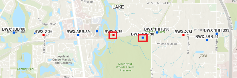
Illinois Historical Aerial Photography Archive, https://tinyurl.com/326tv6vf
Most of the images were taken between 1937 and 1947. Zoom into your area of interest. The blue and red squares indicate the center of the aerial photograph for that area. Click on a square for brief information about the photo, including the date it was taken. Click on the preview image to open the full-size image.
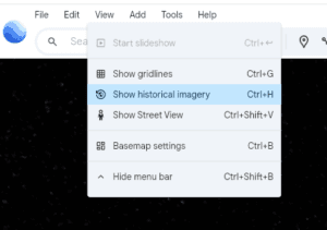
Google Earth, https://earth.google.com/
High-resolution satellite imagery from 1993 to date. Search for or zoom to a location. Then click View –> Show historical imagery. Use the Show Street View icon in the lower-right (looks like a person) to see historical Street View images from 2007, 2012, 2018, and 2024.

After exploring the history of the area from the sky, come back to the ground and check out historical postcards and photographs from the Libertyville Historical Society collection.
Discover more from Cook Memorial Public Library District
Subscribe to get the latest posts sent to your email.
Categories: Local History
Tags: Local History